Monday, November 26, 2007

Regional Connector

The Regional Connector is a potential connection between the Blue and Expo lines and the Gold Line to Pasadena and East Los Angeles. This is an important enhancement to the existing lines, that would allow a one-seat ride into and across downtown Los Angeles, rather than current transfers at 7th and Flower or Union Station to the Red Line or downtown buses.

Metro is beginning an Alternatives Analysis on potential routes. There are many possible routes; the map above (click to enlarge) is my submission, seeking the shortest and quickest route across downtown that serves important destinations.

It would continue in subway from the existing Blue / Expo Line station at 7th Street up Flower Street to 3rd Street, then make a diagonal across Bunker Hill. It would continue east under 1st Street, then curve north under Main Street beneath the City Hall south lawn.

North of Temple Street it would transition from shallow subway to aerial by Los Angeles Street at Aliso Street. The final section would be aerial along Aliso Street to an aerial half grand union with the Gold Line at Aliso and Alameda, to allow trains to go in all directions.

Potential subway station locations are:

  • Flower Street at or north of 5th Street, which also serves southern Bunker Hill via existing escalators;
  • Around Grand Avenue and 2nd Street, serving northern Bunker Hill (hopefully part of the redevelopment project there);
  • By City Hall either on 1st Street around Spring Street or on Main Street near Temple Street.

Add Olympic lane

The LA Times announced today, "Villaraigosa unveils traffic plan for Pico and Olympic." Here's what it would do:

The first step in the mayor's plan would be to immediately begin to eliminate parking on both streets during rush hour. Then, beginning next year, traffic lights would be re-timed so that those traveling west on Olympic and east on Pico would be rewarded with longer green lights. Those driving in the other direction might see their rides take longer.

This makes a lot of sense, to synchronize the signals in the favored direction, without the expense and disruption of Allyn Rifkin's Olympic-Pico one-way proposal last spring. I'd look at it differently, though, rather than take their next step in the one-way direction:

If those two steps speed up traffic, mayoral aides say the city might take an additional step and restripe both streets, so most lanes on Pico would be for eastbound motorists, while westbound lanes would predominate on Olympic.

Think of I-405 as a north-south wall across the Westside, with limited openings that have become major bottlenecks (map, right). Once east of the 405 in the afternoon you find traffic frees up.

This leads to a simple short-term bottleneck-reliever, while we wait for completion of the Expo Line and Wilshire subway. Olympic Boulevard has four lanes westbound but three lanes eastbound between Century City and two blocks west of the 405, presumably from when Century City was a bigger commuter destination than Santa Monica.

The simple bottleneck-reliever is to add a fourth eastbound lane to Olympic from west of Barrington to Sepulveda, as shown below (original map). This section has the same 110-foot right-of-way and 86-foot pavement, but only three lanes in each direction plus curb parking. (To fit nine lanes under the 405 could require a slight narrowing of the sidewalks, but Santa Monica Boulevard fits nine lanes in a 100-foot right-of-way and 88-foot pavement under its I-405 bridge).

Thursday, November 15, 2007

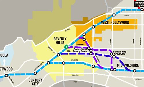
Purple Line subway route options

Here's a short version of my Scoping comments submitted for Metro's Westside Extension.

Route options north of Wilshire Boulevard: There are multiple major destinations north of Wilshire Blvd. that may be more important to serve than Wilshire itself, if end-to-end running time isn’t seriously slowed. These include Farmers Market / The Grove / CBS; Cedars-Sinai Medical Center / Beverly Center; and West Hollywood / Pacific Design Center. I sketched three potential route options to serve them onto their map (above). Based on the existing Red Line schedule I estimate their additional travel time at only 1-3 minutes, so they appear well worth considering.

Beverly Hills – Hollywood Connection: I consider the Wilshire corridor primary, but also find a connection from Beverly Hills via West Hollywood to Hollywood very important. That area has no easy freeway access, and could strongly benefit from a rail transit link, for travel between the Westside and Hollywood or the San Fernando Valley. Perhaps it should be a separate light rail line, on the surface where the old Pacific Electric right-of-way still exists, then tunneled the rest of the way from West Hollywood to Hollywood & Highland?

North-South Corridor: The concurrent Crenshaw-Prairie corridor study’s northern boundary is Wilshire Blvd. Is there a way within the scope of the Westside Extension study to consider a single north-south line from LAX to Hollywood? Such a line could use some combination of Crenshaw, La Brea, Fairfax, and/or San Vicente to connect Exposition & Crenshaw to Hollywood & Highland.

I-405 Corridor: Transit along the I-405 corridor from the San Fernando Valley to Westwood, LAX, and the South Bay is critical and missing. The current Metro LRTP suggests only BRT along the I-405 HOV lanes, and no rail line. An effective interface between the Wilshire corridor and the I-405 corridor (interim BRT, future rail) is very important to consider. Good access to the UCLA campus is also obviously important.

West of I-405: A Wilshire subway may not extend west of Westwood, given its high capital cost and the lesser development density in Santa Monica. Western terminus locations to consider beyond Westwood include one more station on Wilshire between Federal and Bundy in West Los Angeles, to allow Westside access to the subway without needing to cross the 405, and in Santa Monica, the Expo Line's Bergamot Station, Wilshire & Ocean, or the Expo Line’s terminus around Colorado & 4th.